Test according to the method "Compasses"
Description of the test "Compasses"
Test Description
With the help of the test according to the "Compasses" method, the ability to spatial representation is assessed, that is, the ability to remember and operate in the imagination with objects and spatial relationships between them. This technique is recommended for assessing logical thinking, since the spatial representation is interconnected with logical thinking, at least in terms of solving such problems as determining the direction of the cardinal points based on given conditions. This test poses 50 tasks for the subject to determine the cardinal directions, which are indicated by an arrow inside conditional compasses with a given random direction on the scale. The test is used to evaluate the professional skills of pilots and other professions that require good spatial awareness.
Test execution:
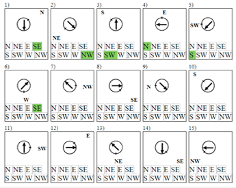
After clicking on the "Take the test" link, you will be taken to a page with 25 (in the simplified version of the test) or 50 (in the standard version of the test) compasses with a random direction of the arrow and a single risk on the compass scale with the indicated direction of the cardinal direction to which this risk is directed. The subject is required to determine and mark the direction of the cardinal direction, which is indicated by the arrow inside each compass, taking into account the direction indicated by the risk on the scale of these compasses. For example, if the compass scale mark is directed to the right and points to the northeast (NE), and the arrow inside the compass looks to the right and down, the subject must mentally turn the compass, following the direction indicated on the compass scale, and determine which side of the world the arrow points to - in this example it will be west (W). Having found out the direction of the light, you should select in the table under each compass the corresponding cell with the code for the direction of the cardinal direction. The code for designating the cardinal points: NW - northwest; N - north; NE - northeast; E - east; SE - southeast; S - south; SW - southwest; W - west. The time to complete the test is limited - for the standard version of the test for 50 tasks - 5 minutes, and for the simplified version for 25 tasks - 2.5 minutes.
Result Calculation
The result of the test according to the "Compasses" method depends on the number of correct answers and the time spent on passing the test. The following indicators are calculated:
- Work speed (S):
S=P-n/T - compasses per minute, where:
P (performance) - total number of viewed compasses;
T - test execution time;
n - the number of errors - incorrectly determined directions of the compass needle; - Success Rate (A):
A=(C-W/C+O)/S - conventional units, where:
C - the number of all marked compasses;
W - number of incorrectly marked compasses;
O - the number of compasses to be noted;
S - total number of compasses viewed.
By the number of points, which is determined by the number of correct answers, you can get a rough idea of your abilities of spatial representation and logical thinking.
Scoring table (based on the number of correct answers):
| Points: | 1 | 2 | 3 | 4 | 5 |
| Performance: | 1-6 | 7-10 | 11-15 | 16-20 | 21-24 |
| Points: | 6 | 7 | 8 | 9 | 10 |
| Performance: | 25-29 | 30-36 | 37-46 | 47-49 | 50 |
Start of the test "Compasses":
© Oleg Akvan
metodorf.com
Comment block
John doe
2024-06-17 10:51:58
34) is incorrect arrow is pointing 135 degrees counter clockwise from North East which is places in a perfectly straight manner, it says answer is North not West.
Also a 10 answer practice question should be used since my speed significantly increased after the first few.
Admin
2025-03-21 12:15:33
Hello, John doe. Unfortunately, it is difficult to verify whether such an error really exists. At the moment, we have not been able to detect an error in the compass directions. We have taken into account your opinion about the need for a training version of the test with 10 compasses, and have added such a test.
Leave a comment:
Weekly Games & Trainers Collection: